
Search
Dungog
AreaNew South Wales
Dungog
Area Area
Showing the first 43 results out of a total 43
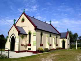
Clarence Town
UrbanPopulation: 1994 | Dungog
The area which became known as Clarence Town was first settled by white settlers following the...
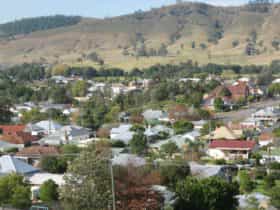
Dungog
UrbanPopulation: 2025 | Dungog
Set in rolling valleys at the foothills of the Barrington Tops is a picturesque necklace of...
East Gresford
UrbanPopulation: 306 | Dungog
Gresford
UrbanPopulation: 245 | Dungog
The town of Gresford was named by its Welsh settlers after a town on the Allyn...
Paterson
UrbanPopulation: 892 | Dungog
Paterson is one of the historic towns of the Hunter Valley, 18 kilometres north of Maitland....
Torryburn (Dungog)
RuralPopulation: 142 | Dungog
The locality of Torryburn, about six kilometres south of East Gresford, is the setting for behind...
Alison (Dungog)
RuralPopulation: 76 | Dungog
Allynbrook
RuralPopulation: 64 | Dungog
Bandon Grove
RuralPopulation: 119 | Dungog
Bendolba
RuralPopulation: 205 | Dungog
Bingleburra
RuralPopulation: 25 | Dungog
Brookfield
RuralPopulation: 205 | Dungog
Cambra
RuralPopulation: 30 | Dungog
Carrabolla
RuralPopulation: 10 | Dungog
Chichester
RuralPopulation: 29 | Dungog
Eccleston
RuralPopulation: 35 | Dungog
Fishers Hill
RuralPopulation: 36 | Dungog
Flat Tops
RuralPopulation: 25 | Dungog
Fosterton
RuralPopulation: 108 | Dungog
Glen Martin
RuralPopulation: 172 | Dungog
Glen William
RuralPopulation: 122 | Dungog
Halton
RuralPopulation: 18 | Dungog
Hanleys Creek
RuralPopulation: 4 | Dungog
Hilldale
RuralPopulation: 195 | Dungog
Lewinsbrook
RuralPopulation: 43 | Dungog
Lostock
RuralPopulation: 58 | Dungog
Main Creek
RuralPopulation: 88 | Dungog
Marshdale
RuralPopulation: 44 | Dungog
Martins Creek
RuralPopulation: 388 | Dungog
Mount Rivers
RuralPopulation: 43 | Dungog
Munni
RuralPopulation: 40 | Dungog
Salisbury
RuralPopulation: 58 | Dungog
Stroud Hill
RuralPopulation: 28 | Dungog
Sugarloaf
RuralPopulation: 71 | Dungog
Summer Hill (Dungog)
RuralPopulation: 55 | Dungog
Tabbil Creek
RuralPopulation: 40 | Dungog
Underbank
RuralPopulation: 34 | Dungog
Upper Allyn
RuralPopulation: 12 | Dungog
Wallaringa
RuralPopulation: 11 | Dungog
Wallarobba
RuralPopulation: 172 | Dungog
Webbers Creek
RuralPopulation: 30 | Dungog
Wirragulla
RuralPopulation: 30 | Dungog
Vacy
RuralPopulation: 625 | Dungog
Vacy came into existence around 1828 as a private township established by the Cory family. John...
Showing the first 43 results out of a total 43